Corridor Traffic Forecasting
Corridor Traffic Forecasting produces the information needed for traffic engineers to determine the required geometric configurations within a corridor to meet the future traffic demand. Traffic forecasting is required before establishing a new alignment or improving existing facilities. Corridor models are special application models that are validated to forecast traffic for a certain corridor and usually include more details than an urban or regional model. The models validated to forecast general corridor traffic for systems planning purposes should be reviewed to ensure that they have the required project details for Project Traffic Forecasting using design traffic criteria.
Corridor Traffic Forecasting is needed to determine future traffic volumes and long range system data needed for the areawide highway or transportation network. A corridor may be designated by a local government in its Comprehensive Plan.
A corridor study containing a Corridor Traffic Forecast may document the purpose and need for new or upgraded transportation facilities within the corridor. Corridor Traffic Forecasting is needed for Strategic Intermodal System (SIS) Master and Action Plan reports, and major transportation investments required by federal regulations in metropolitan areas. For planning applications, the model is often used for changing or amending approved plans such as the Local Government Comprehensive Plan (LGCP) or the Long Range Transportation Plan (LRTP), provided by the local Metropolitan Planning Organization (MPO), Transportation Planning Organization (TPO), or Transportation Planning Agency (TPA). Projects identified through the Corridor Traffic Forecasting Process will require a Project Traffic Forecast. The appropriate District Director or his/her designee(s) will be responsible for carrying out the Corridor Traffic Forecasting Process, unless assigned elsewhere by the District Secretary or their respective designee(s).
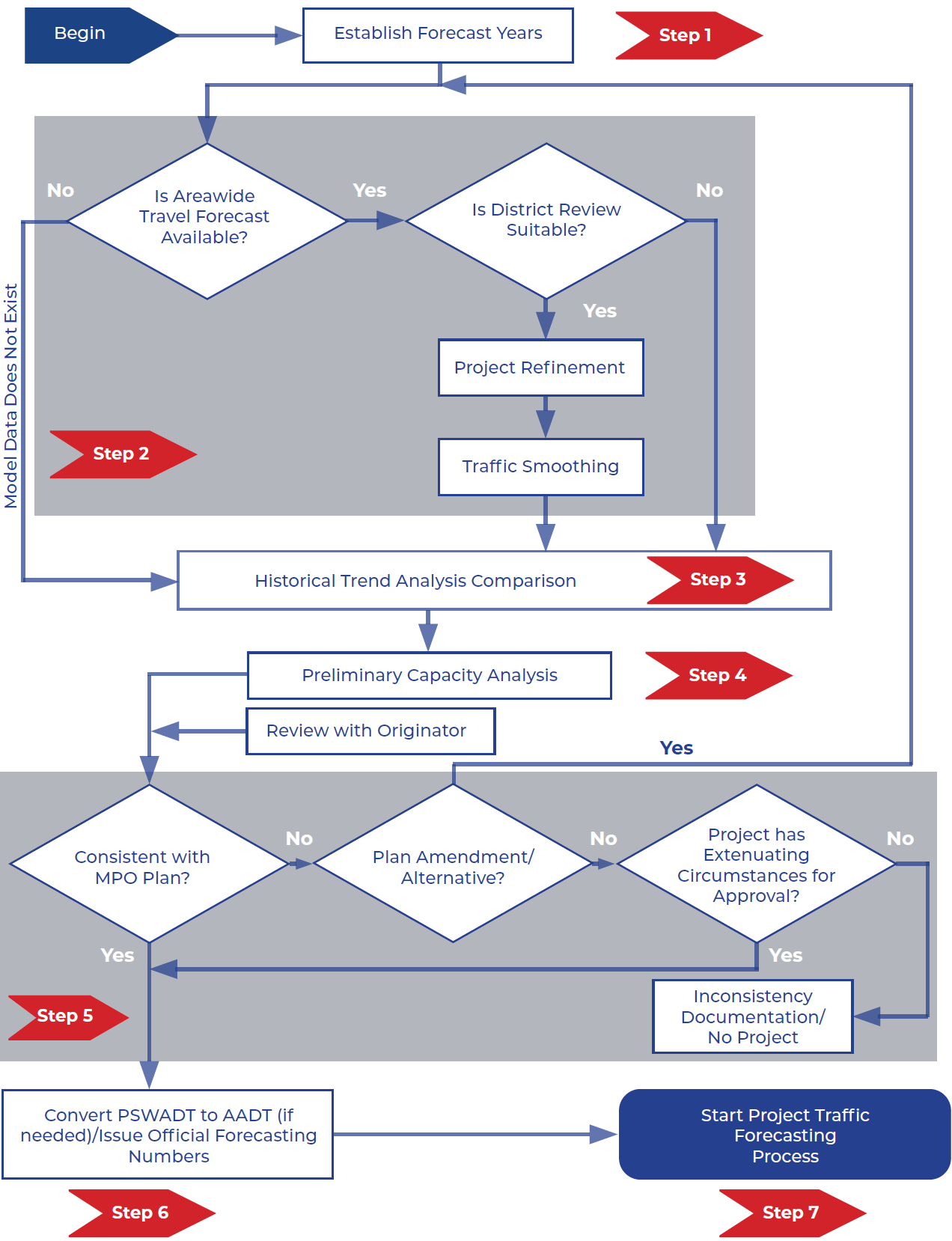
Figure 4-1 illustrates the seven-step Corridor Traffic Forecasting Process.
Project Traffic Forecasting Process
Project Traffic Forecast projections use the Corridor Traffic Forecast. The Project Traffic Forecast Process estimates traffic conditions used for determining the geometric design of a roadway and/or intersection and the number of 18-KIP ESALs that the pavement will be subjected to over its design life. This process is different from Corridor Traffic Forecast in that it is site specific, covers a limited geographic area, and is more refined.
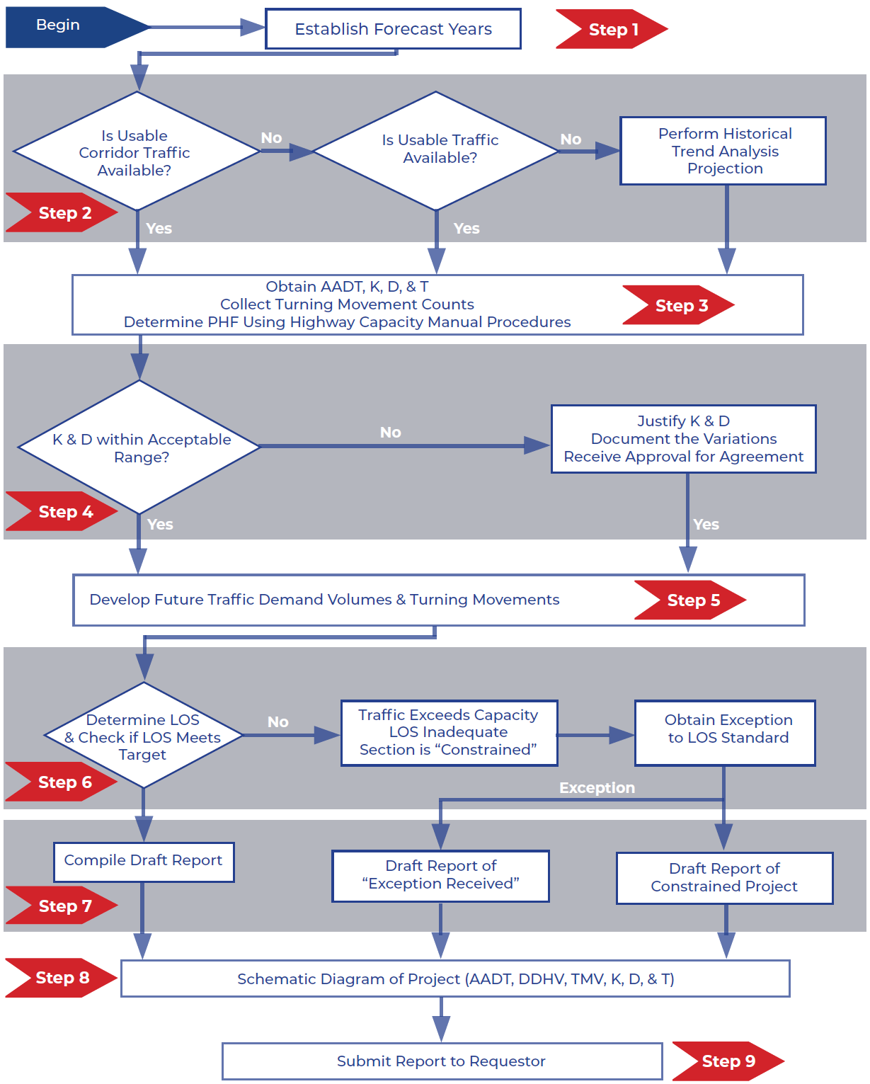
The Project Traffic Forecasting Process consists of nine steps which are shown in Figure 4-2 and explained in greater detail throughout this Handbook. While the Corridor Traffic Forecast may be detailed enough to identify the needs for specific improvements, the final Project Traffic Forecasting data needed for a specific project may require more refined or specific project traffic analysis. Project traffic studies identify specific link volumes, turning movements, and other project-specific data necessary for the geometric design of, and operational improvements to roadways or intersections. The project traffic process helps identify traffic conditions and turning movement volumes used for designing the configuration and number of lanes for proposed projects, as defined in the FDOT Adopted Five Year Work Program. Project traffic forecasts are used to identify the project traffic developments for the SHS, Interchange Access Requests (IAR), PD&E studies, Master and Action Plans for SIS facilities, RRR projects, lane repurposing, bridge replacement, approaches to bridges, new roadway projects, and major intersection improvements.
Establishing Forecast Years
For Project Traffic Forecasting purposes, the existing year is the year when system data is collected to evaluate the existing conditions and establish the purpose and needs of a project. The system data typically includes roadway conditions, traffic counts, traffic controls, such as signal timing plans, delays and queue lengths, and crash data. In some cases, the model base year coincides with the year when the study is conducted, but it could be several years earlier. It serves as the reference point for future year traffic forecasting.
For model development purposes, the base year is the year whose traffic conditions the model is adjusted to replicate. The base year of a model is often associated with the MPO/TPO/TPA’s LRTP update cycle, and the most recent US Census year is often used as the base year due to the availability of accurate population information. In many cases, the model base year is different from the project base year. Likewise, the forecast year of the model could be different than the design year of the project. Standard data processing procedures, such as linear interpolation or extrapolation, should be used to ensure that the model provides traffic forecasts for both the opening and design year of the project.
The following guidelines should be followed to establish traffic forecasting years and develop traffic forecasts for the opening and design years.
- Existing Year – the most recent year when traffic counts and other traffic operational data (e.g., O-D, travel time, and delays) are collected or available. It is typically the year when the study is conducted or one year before the study is conducted.
- Opening Year – the first year after a project is scheduled to be open to the public and when the new traffic pattern stabilizes.
- Interim Year(s) – years between the Opening Year and the Design Year, typically ten (10) years after the opening year.
- Design Year – the year for which a roadway is designed. It is usually 20 years for capacity projects and 10 years for operational projects from the Opening Year.
The FDOT Project Manager and other relevant stakeholders should be consulted to establish analysis years before the project begins.